Lithium Springs Project
Fuse Secures 100% Interest in 108 Placer Claims in Black Rock Desert, Exploring Potential Lithium Brine and Clay Deposits in Nevada
Washoe
Tonopah, Nevada
100%
Ownership
858 Hectares
Total Area
108
Placer Claims
Overview
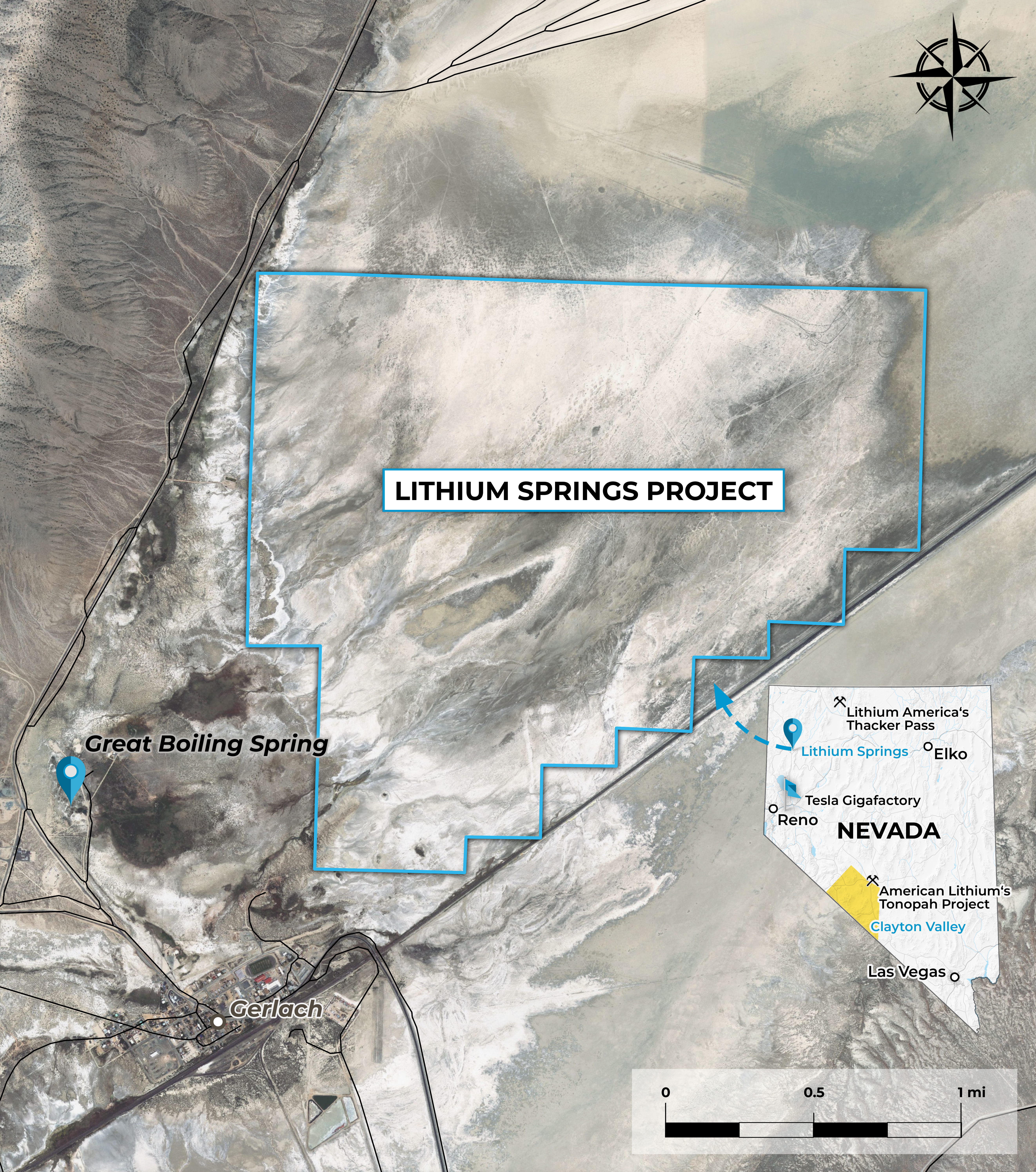
In February 2023, Fuse entered a Purchase and Sale agreement to acquire a 100% interest in 108 placer claims. The claims cover approximately 858 hectares of playa and alluvial fan located at the south end of the Black Rock Desert outside of the hamlet of Gerlach in Washoe County, Nevada.
In February 2023, Fuse entered a Purchase and Sale agreement to acquire a 100% interest in 108 placer claims. The claims cover approximately 858 hectares of playa and alluvial fan located at the south end of the Black Rock Desert outside of the hamlet of Gerlach in Washoe County, Nevada.
The project is located at the southern end of Black Rock Desert, Nevada, about 132 air-line km north-northeast of Reno, Nevada. Black Rock Desert basin is about 110 km long and up to 25 km wide at the widest point. The central playa measures about 50 km northeast – southwest and 10 km southeast – northwest. The western arm of the Black Rock Desert covers an area of about 2,000 square kilometers and contains 5 of the 30 currently listed Known Geothermal Resource Areas in Nevada.
The property covers an area of playa underlain by a moderately deep basin interpreted from gravity and seismic surveys indicating a maximum thickness of valley-fill deposits of about 1,200 m/ 3,600 ft. A high salt content prevents any significant vegetation from growing on the playa surface. Locally, the basin is being fed in part by boiling springs and siliceous sinter containing strongly anomalous Lithium values (up to 3.5 ppm) that flank the property on the west side. (U.S. GEOLOGICAL SURVEY Open-File Report 81-918.) While these lithium values are well below those of producing lithium bines, they do represent a significant source of metal available for evaporative concentration within the playa basin.
In 2016, a grid soil sampling program was conducted on the property, consisting of 170 sites where samples were collected at 200-meter intervals on lines spaced 400 meters apart. The results showed lithium values ranging from 82.8 to 520 ppm, with a median of 182 ppm, which were significantly higher than the background in the surrounding areas.
The presence of lithium in the active geothermal fluids and surface salts of the Black Rock Desert property, along with the local geologic setting, suggests similarities to lithium brine deposits in Clayton Valley, Nevada, and South America. The geothermal fluids in the nearby area have lithium concentrations in the 3 to 5 mg per liter range, which likely contributed to the surface sampling values.
These preliminary results justify further exploration for a Clayton Valley type brine and/or clay deposit. A reasonable expectation for the Company’s First Phase exploration program would be to re-sample the area, complete a geophysical survey, and conduct a phased exploration program consisting of surface sampling, auger or push drill water sampling, and geophysical work to identify drilling sites for an initial drill test of the property. A subsequent Phase two exploration program may include additional surface and sub-surface sampling in the form of drilling, to test the property for lithium-bearing brine and/or clay deposits.
Project Location
The project is located at the southern end of Black Rock Desert, Nevada, about 132 air-line km north-northeast of Reno, Nevada. Black Rock Desert basin is about 110 km long and up to 25 km wide at the widest point. The central playa measures about 50 km northeast – southwest and 10 km southeast – northwest. The western arm of the Black Rock Desert covers an area of about 2,000 square kilometers and contains 5 of the 30 currently listed Known Geothermal Resource Areas in Nevada.
The property covers an area of playa underlain by a moderately deep basin interpreted from gravity and seismic surveys indicating a maximum thickness of valley-fill deposits of about 1,200 m/ 3,600 ft. A high salt content prevents any significant vegetation from growing on the playa surface. Locally, the basin is being fed in part by boiling springs and siliceous sinter containing strongly anomalous Lithium values (up to 3.5 ppm) that flank the property on the west side. (U.S. GEOLOGICAL SURVEY Open-File Report 81-918.) While these lithium values are well below those of producing lithium bines, they do represent a significant source of metal available for evaporative concentration within the playa basin.
Exploration Highlights: Soil Sampling, Lithium Presence, and Proposed Phases
In 2016, a soil sampling program covering 170 sites was conducted on the property. Samples were collected at 200-meter intervals on lines spaced 400 meters apart. The results showed lithium values ranging from 82.8 to 520 ppm, with a median of 182 ppm—significantly higher than surrounding background levels.
Lithium presence is evident in active geothermal fluids and surface salts of the Black Rock Desert property. The local geological context resembles lithium brine deposits in Clayton Valley, Nevada, and South America. Geothermal fluids nearby contain lithium concentrations of 3 to 5 mg per liter, likely influencing surface sampling values.
The initial exploration phase would include re-sampling, a geophysical survey, and phased exploration. This involves surface and water sampling, along with geophysical investigations to identify drilling sites for an initial property test. A subsequent Phase two program could involve drilling for additional surface and sub-surface sampling to assess lithium-bearing brine and clay deposits.
Key Takeaways
Prominent
Significant lithium values found in soil samples (median 182 ppm) compared to surroundings.
Indication
Active geothermal fluids and surface salts indicate presence of lithium; geological setting resembles known lithium deposits.
Strategy
Comprehensive exploration plan, including re-sampling, geophysical survey, and drilling, to assess potential lithium-bearing brine and clay deposits.


